Deliverable 4.4 – hazard modelling

The Deliverable 4.4 – Modelling changing pattern of hazard and risk and identifying the return period of the extreme events that the NBSs could safely withstand – assesses the effectiveness of Nature-based solutions (NBSs) in reducing risks at the three demonstrator case stusy sites, namely the Serchio River Basin, the Gudbransdalen Valley and the Pyrenees.
This analysis was carried out by implementing numerical modelling and analyses to map the hazard related to natural phenomena affecting the study areas with and without NBSs implementation. Since most of the natural hazardous phenomena are strongly affected by forcing weather events (e.g. rainfalls, snowfalls, heat waves), hazard modelling was developed for different climatic scenarios, following site-specific approaches, aiming to profitably assess the effectiveness of NBS interventions against the impacts of climate change.
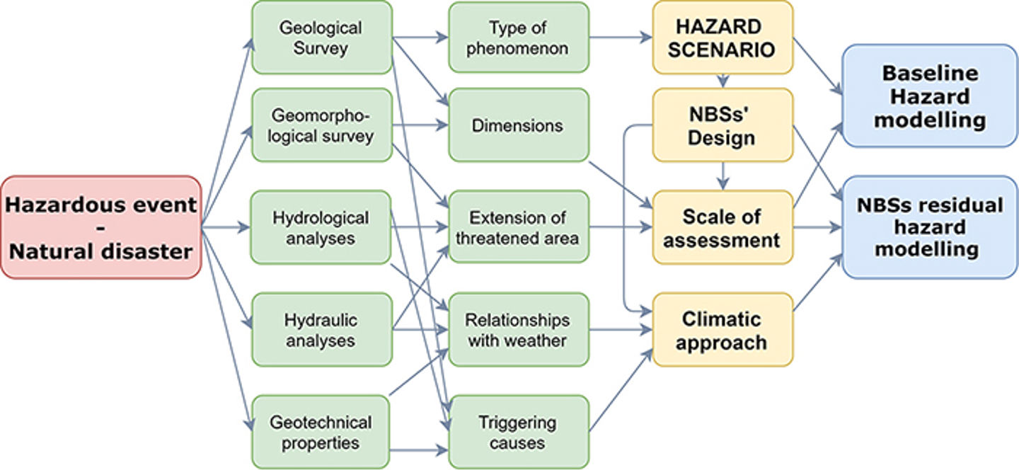
The framework sketched in the figure below summarizes the basic workflow applied to all the investigated cases to address the modelling approaches. Specifically, at each Demonstrator Cases, the following outcomes are discussed.

General scheme for the definition of the modelling scenario
Serchio River Basin
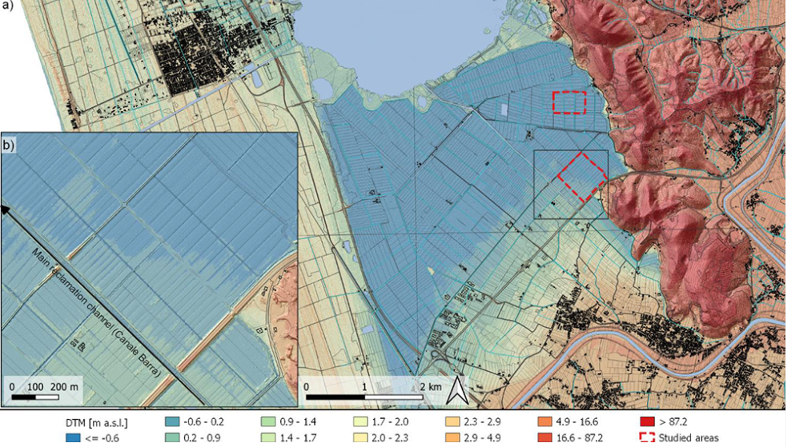
At the Serchio River Basin (Massaciuccoli lake catchment, central Italy), vegetated buffer strips (VBSs) and winter cover crops (WCCs) are adopted in a flat agricultural area, drained by an artificial channel network, to limit runoff and sediment losses responsible for nutrients transport. Results showed that the VBSs significantly reduce runoff and sediment yield, especially where soils are fine-grained and with low organic content. Winter cover crops are more effective on the soil erosion on the same soil types. Coupling the measure is thus considered as the most viable solution. When considering extreme climatic conditions over long periods, results showed that the NBSs are effective on mineral soils, whereas their benefits are negligible on peat soils.
Gudbrandsdalen Valley
At the Gudbrandsdalen Valley site (Jorekstad, Norway), the effects of a levee made of earth in terms of flow depth and velocity reduction was simulated in order to map the flood hazard generated by Gausa River for baseline and NBS scenarios, at varying the soil moisture conditions. Results of simulations showed an ineffective response of the NBSs in the most severe soil moisture conditions. However, good performances of the levee against flooding caused by rainfall events having a return period shorter or equal to 100 years were estimated when setting average soil moisture conditions.
Pyrenees sites
At the Pyrenees sites (Artouste, France and Santa Elena, Spain), rockfall is the primary hazard affecting the main road crossing the France-Spain border. At the Artouste site, rockfall crosses a forested slope; therefore, the developed analysis considered the mitigative effect of the forest, using Rockyfor3D software. Results comparison showed that the current forest structure and NBSs could reduce rockfall peak energies and bounce height but cannot stop many blocks. Therefore, they can be considered as an integrative solution to reduce impacts and costs of other grey solutions. At the Santa Elena site, rockfalls of varying volumes detach from a moraine deposit and cross a limited slope with low vegetation cover. The NBSs implemented in the site consisted of terracing and planting autochtonous bushy and tree species. Results showed that the measures are able to significantly reduce rockfall propagation which, after the NBS implementation, can hardly reach the road quay being, in these occurrences, endowed with low energies and heights.
News item prepared by
- Dr. Geol. Antonio Pignalosa PhD, Research Fellow, antonio.pignalosa@unina.it
- Eng. Carlo Gerundo PhD, Research Fellow, carlo.gerundo@unina.itDepartment of Civil, Architectural and Environmental Engineering, University of Naples Federico II